 Wave Magazine Online Jacksonville University News Hub
So you think you know Florida? The Geography Department at Jacksonville University has a challenge for you.

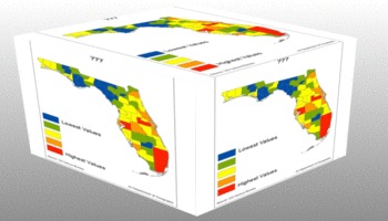
The department has mapped some recently released census data for the state of Florida. Each thematic map in the unique presentation illustrates the geographic pattern of a variable for the state by county. The red counties represent the highest values for that variable, the blue counties represent the lowest value, with yellow counties representing values closest to the state average.
“The data were gathered and analyzed by the JU Department of Geography as part of our ongoing research to monitor demographic trends in the state and provide relevant maps for the business and educational community,” said Dr. Ray Oldakowski, Professor of Geography.
He offers a few key findings:
- Two huge population concentrations exist in the state. Southeast Florida, with nearly 6 million people, and the I-4 corridor with more than 5 million people.
- There is a stark contrast in ethnic and language diversity in the state along either side of the I-4 corridor.
- The state’s largest metro areas like Miami, Tampa, Orlando, and Jacksonville have young, well educated populations which bodes well for economic growth.
See if you can guess the variable being mapped based on the similarities of the counties that have the same color. The variable and values follow the unlabeled maps, along with an explanation for the geographic pattern. Start your quiz below. Enjoy!